Cycling routes through the suburb and to schools
In 2020 there are no published cycle routes in Deakin. Dark blue are principal routes on ACT Govt active travel map. Pale blue are ‘Main intended’ routes. Perhaps we should seek a commitment from candidates in the 2020 ACT election for their construction
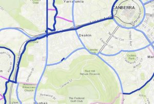
The peripheral track at foot of Red Hill could be a useful link to connect Kent St and Flinders Way
DRA Bike Survey results and consultations
A survey conducted last year by the DRA identified the following cycling issues as important:
- Cycling routes through the suburb,
- Facilitating cycling routes to schools
- Improving safety for cyclists
Routes to schools
Upgrade local and main routes identified were
- A bike lane for Melbourne Avenue to link up with State Circle and the Parliamentary Triangle.
- would facilitate access to the school.
- Currently there is a bike lane marked on Hobart Avenue.
- But not on the Active Travel Infrastructure map as a local endorsed route.
- Lane facilitates access to Forrest Primary however it does not link with the main intended route through Forrest. Extending this route through to Collins Park would provide a clear route to the school. Intersections between Collins Park and Hobart Avenue are challenging.
Improving safety for cyclists
Hot spots and signage issues identified were.
- Access to and safety up Red Hill
- A 40 km speed limit has been put in on the branch road off Gowrie Drive, going down to the Federal Golf Course. It was recommended that this 40 km speed limit be put in on Gowrie Drive for the route up to Red Hill lookout to enhance safety of the walkers and cyclists.
- Roundabout at the foot of Red Hill – (Mugga Way, Stonehaven Cres, Strickland Cres and Gowrie drive intersection).
- Current signage obscures visibility of cyclists with cars. Cyclists coming down from Red Hill are obscured by the “Deakin Shops” sign placed in the middle of the road at the roundabout. It obscures the view up Gowrie Drive for the east-bound motorist on Stonehaven/Mugga Way.
- Roundabout visibility at the Hopetoun/Stonehaven roundabout
- Cyclists turning right off Stonehaven onto Hopetoun the sign in the median strip on Hopetoun can conceal cyclists turning. Placing the signage in a different position would improve safety for cyclists.
For both roundabouts marking the left edges of the road as it enters each side of the roundabouts with the green bike line markings similar to Adelaide Ave. Green cycle lines are currently used on the roundabout at the intersection of Flynn and Alexandrina Drives Yarralumla (back of the Hyatt).
This will help draw driver attention to cyclists using the roundabout and give them better vision of all vehicles to whom they must give way.
- Cyclists turning right off Stonehaven onto Hopetoun the sign in the median strip on Hopetoun can conceal cyclists turning. Placing the signage in a different position would improve safety for cyclists.
- Deakin Shops between Mc Gregor Street and Grose Street.
- The narrowing of Hopetoun Cct at the end of Gawler Cres, becomes a bottle neck and drivers try to squeeze past cyclists who are left trying to navigate around
Fast-track bike lanes to boost jobs and take advantage of lockdown-induced bicycle sales
Australia’s peak cycling organisations are calling on governments to capitalise on a surge in lockdown-induced bicycle sales by fast-tracking the construction of all 750 km of planned bike lanes around the country, a move that would promote physically distanced commuting while taking “tens of thousands” of cars off city roads. Such a move would promote social distancing, take thousands of cars off roads and make it safer for riders.